


 Uranium discovery threatens ancient indigenous cave art guardian.co.uk
Please note: The following is 2013 data.
Across Australia there are more than 100,000 rock-art sites, with millions of unique works from the First Nations peoples, created over tens of thousands of years. Mining activities and exploration has and is continuing to threaten significant sites.
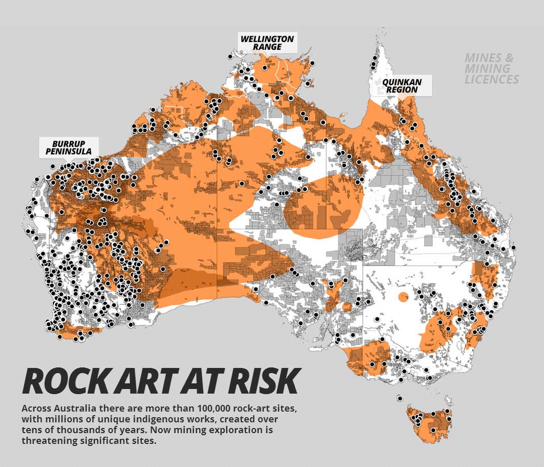
Data was collected from each state and territory as well as national mining data. Due to the differing terminology between states there is limitations in what is displayed to similar data sets. Map data was downloaded between February 22 and March 5, 2013, so the map is a snapshot of mines and mining activities for that period. Map Source and Credits
- Rock-Art Regions: Significant rock-art regions according to Professor Paul Taçon, Chair in Rock Art Research, Griffith University. Overlapping regions indicate multiple rock-art styles.
- Mines: Includes all mine types. WA data includes major resource projects (mines and mining related infrastructure). NT data includes some mines still at feasibility study stage. State and territory data was used where available; otherwise national data was used.
- Pipelines: Includes petroleum, liquids, and gas pipelines based on available state and territory data.
- Leases and Licences: Includes current exploration licences, tenements, claims, leases and licences based on available state and territory data. We have excluded anything labelled as 'application' or where relevant fields are 'null'.
Sources of mining data
- National: http://www.australianminesatlas.gov.au/?site=atlas
Layers used:
- Operating Mines - All commodities
- QLD: http://mines.industry.qld.gov.au/geoscience/interactive-resource-tenure-maps.htm
Layers used:
- Petroleum Pipeline Licences
- Operating Coal Mines
- Petroleum Leases
- Mining Leases
- Mining Exploration Permits
- Petroleum Exploration Permits
- Mineral Exploration Permits
- NSW: http://minview.minerals.nsw.gov.au/mv2web/mv2
Layers used:
- Operating Mines
- Petroleum Titles
- Mineral Titles
- Coal Titles
- ACT: No mining activity.
- VIC: http://mapshare2.dse.vic.gov.au/MapShare2EXT/imf.jsp?site=geovic
Layers used:
- Exploration Licences
- Mining Licences
- Gas and Fuel Pipelines
- Petroleum Permits
- TAS: http://www.mrt.tas.gov.au/portal/page?_pageid=35,831126&_dad=portal&_schema=PORTAL
Layers used:
- Leases
- Licences
- SA: https://sarig.pir.sa.gov.au/Map
Layers used:
- Major Mines
- Petroleum Production Licences
- Petroleum Exploration Licences
- Mineral Exploration Licences
- Mineral Leases
- Mineral Claims
- Extractive Mineral Leases
- Gas Pipelines
- Gas and Liquid Pipelines
- Liquid Pipelines
- WA: http://geodownloads.dmp.wa.gov.au/datacentre/datacentreDb.asp
Layers used:
- Operating Mines
- Petroleum Pipelines
- Mineral Tenements - Current
- Petroleum Titles
- NT: http://geoscience.nt.gov.au/GeosambaU/strike_gs_webclient/default.aspx
Layers used:
- NT Mines
- Mining - Granted Exploration Licences
- Petroleum - Granted Exploration Licences
- Granted Mining Tenements
Source and credits:
The Global Mail
Research by Clare Blumer. Design and development by Jamie Ferguson, Andrew Cobby and B.J. Rossiter
Add new comment